Large-scale digital soil maps on pilot areas created by the usage of the
Profil-level Database of Hungarian Large-Scale Soil Surveys (Hungarian acronym: NATASA)
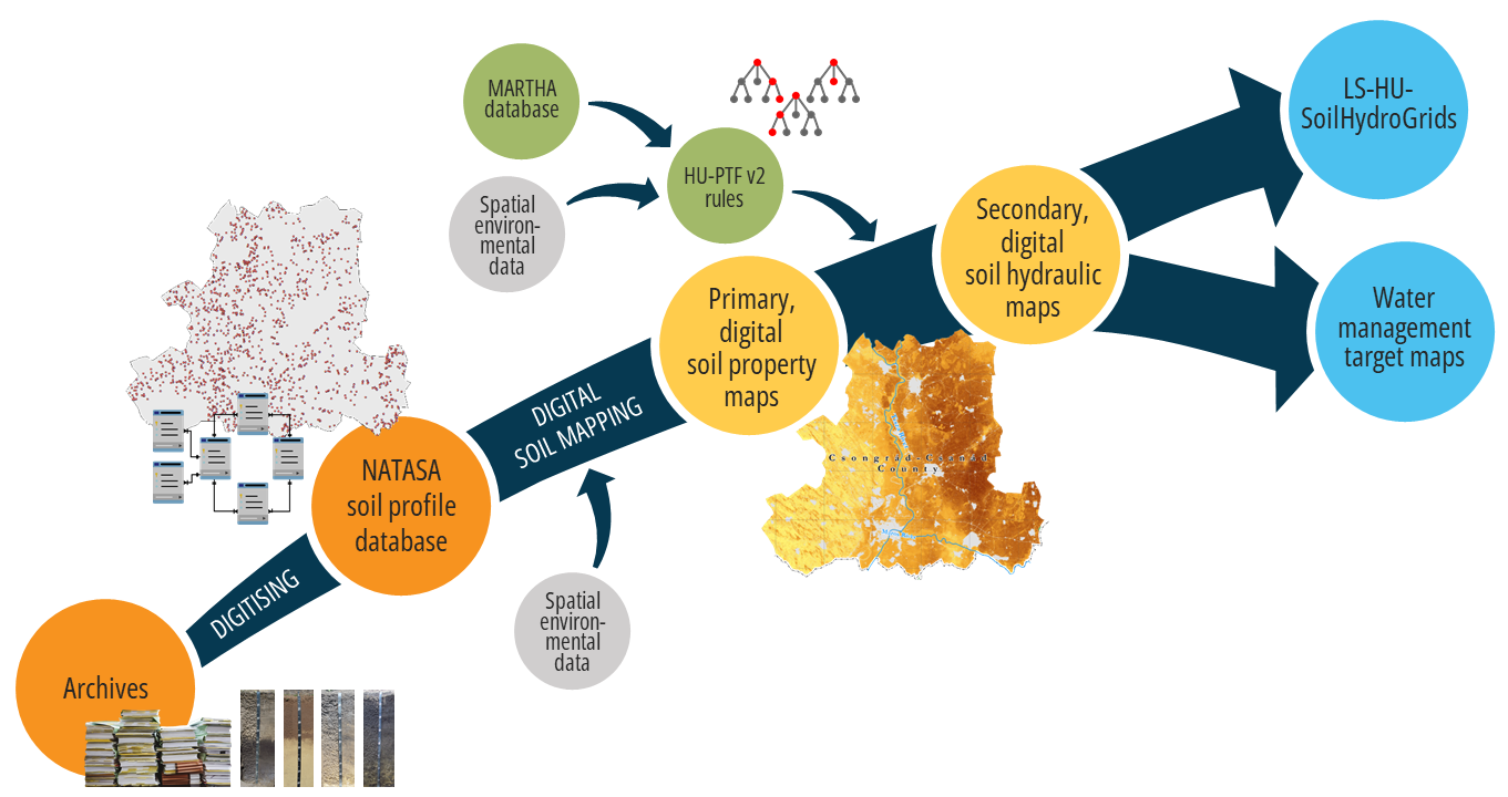
The DOSoReMI.hu (Digital, Optimized, Soil Related Maps and Information in Hungary) initiative has begun the transformation of Hungary’s soil spatial data infrastructure by rethinking the framework for the production and provision of soil spatial data. This was followed by the launch of the Profil-level Database of Hungarian Large-Scale Soil Surveys (NATASA) to preserve and digitally process the available legacy data originating from large-scale soil surveys conducted in Hungary between the 1960s and 1990s. NATASA is considered as the fundamental basis for further steps towards higher spatial resolution digital soil maps. Taking into account the objectives of various projects, digitization work is underway in pilot areas (Balaton catchment area, Csongrád-Csanád county, etc.), and based on the processed data, the first step is to create digital primary soil property maps with a spatial resolution of 25 meters, which will then be used to derive secondary property maps at the same spatial resolution.
NATASA is a continuously expanding soil profile database based on the uniform processing of high-resolution, potentially nationwide legacy soil data. The current database contains digitized data from approximately 148,000 soil layers of 37,000 soil profiles. Its current territorial representativeness is heterogeneous: data for 5 of 19 Hungarian counties are fully available, and for a further 6 counties partly; the degree of processing and territorial coverage constantly expanding. NATASA was created by harmonizing three soil data sources of different origins, based on the nomenclature guide prepared for the implementation of large-scale soil mapping in 1989. The database is based on (i) large-scale genetic soil mapping covering agricultural areas at a scale of 1:10,000, which began in 1962; (ii) detailed soil profile surveys related to the national land evaluation between 1980 and 1985; and (iii) genetic soil mapping for land classification purposes from 1986 to 1991. The profile database, which is made up of these three sources, can be divided into two parts: field survey reports (profile descriptions) and laboratory test results. The field documentation includes the location of the soil profiles and a description of their environment, a general description of the profile, and the morphological characteristics of each genetic soil horizons, laboratory measurement data are also recorded and stored by soil horizons. The georeferenced soil profile data has been professionally reviewed in accordance with the principles of the national genetic soil classification system set out in the legislation. Within this framework, a rule-based filtering system developed for soil types and subtypes assists in the verification and uniform interpretation of the data.
Based on NATASA observation data, spatial predictions were made in 25 m spatial resolution for the four counties (Somogy, Vas, Veszprém, and Zala) belonging to the Balaton catchment area, as well as for Csongrád-Csanád county for genetic soil type according to the Hungarian soil classification system and for several primary soil properties (organic matter content, chemical properties, lime content, physical texture categories derived from Arany-type plasticity index). The primary soil property maps were prepared in two depth divisions: on the one hand, standard layers according to Global Soil Map (GSM) specifications (0-5, 5-15, 15-30, 30-60, 60-100 and 100-200 cm) and, on the other hand, in the layering frequently used in domestic practice (0-30, 30-60, 60-100 and 100- 200 cm). Since no data were collected during the surveys on certain important primary soil properties (including particle size fractions), the spatial data for these were generated by developing estimation methods based on the survey data (https://doi.org/10.1016/j.geoderma.2025.117178). This resulted in the creation of maps for clay, sand, and silt content, as well as category map for USDA soil texture classes.
The next step is to digitally map secondary soil hydrological characteristics (saturated water content, water content at field capacity and wilting point, saturated hydraulic conductivity and Mualem‐van Genuchten parameters for the description of the moisture retention curve) based on large-scale primary soil property maps and specifically developed prediction methods similarly to HU-SoilHydroGrids 3D Soil Hydraulic Database. The resulted collection of digital hydrological maps represent a large-scale, three-dimensional soil hydrological database (LS-HU-SoilHydroGrids) for each pilot area, and on the other hand, they form the basis for further water management target maps, which can contribute, for example, to clarifying the drought and waterlogging sensitivity of agricultural areas, as well as providing a professional foundation and planning support for planned irrigation developments.